The Forecasts
Friday, July 15, 2011
Well before the starting guns sounded on July 16, the Storm Prediction Center (SPC) in Norman, Oklahoma was anticipating the formation of an organized cluster of severe thunderstorms near the upper Great Lakes between mid-day on Sunday and Monday morning. The staff of the SPC, located in Norman, Oklahoma, are the nation's expert in identifying conditions favorable for the development of severe weather. Each day they issue a suite of forecast products to alert the public to areas where the potential for severe weather exists, as well as the nature of the storms that might develop.
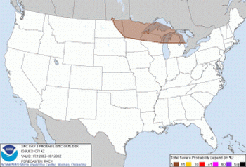
The SPC's Day Three Convective Outlook (Outlook) issued at 03:14 am on July 15th covered the 24-hour period beginning at 8:00 am Sunday, July 17. The discussion portion of the Outlook mentioned the possibility that a storm complex could "backbuild and or develop east southeast into parts of northern Minnesota, northern Wisconsin, and upper and northern lower Michigan on Sunday afternoon". The accompanying Probabalistic Outlook (figure 1) highlighted the broad area across the upper Great Lakes where the development of severe weather was anticipated. The potential for organized severe weather late on Sunday night or early Monday morning was also included in the briefing offered by Chris Bedford of Sailing Weather Service during the skipper's meeting on Friday night. The analysis that follows will show that the area identified on this graphic was remarkably accurate in pinpointing the area in which the squall line would develop and travel.
Saturday, July 16, 2011
The Day Two Outlook issued on Saturday morning (July 16th) and valid starting on Sunday morning was very similar to the previous day's version, and continued to focus on the upper Great Lakes as the area for potential formation of severe weather. The discussion noted that the temperature, moisture and wind parameters, in tandem with an approaching cold front, were conducive to the threat of hail and heavy rainfall across northern Wisconsin and northern Michigan. The accompanying Probabalistic Outlook (figure 2) showed an increase in the probability of severe weather from 5% in Friday's Outlook to 15%, reflecting a moderate increase in forecaster confidence. The surface forecast valid at 8:00 pm on Sunday night (figure 3) shows the expected cold front moving into the area.


Sunday, July 18, 2011
On Sunday morning, the Day One Convective Outlook (figure 4) indicated a slight risk for severe weather in a broad area extending from northern Montana east into the upper Great Lakes. The Outlook included an enhanced threat of large hail and damaging winds for most of Lake Michigan. Specifically, the Outlook text mentioned that if a complex of severe thunderstorms were able to develop over the upper Mississippi Valley, the system could reach as far south as Chicago by Monday morning. In addition, the Hyrdrometeorological Prediction Center (HPC) was anticipating significant rainfall across the region, with over an inch expected in northern Wisconsin. By late Sunday night, a large portion of the Chicago-Mac participants would be sailing in the area with the greatest potential for severe weather.


While the synopsis portion of the Open Lake Forecast issued by the Romeoville, IL NWS office at 9:58 am on Sunday morning mentioned the approaching cold front, it did not include a specific reference to the potential for organized severe weather across the northern portion of the lake.
| .SYNOPSIS...HIGH PRESSURE OF 30.2 INCHES RIDGING FROM THE MID
ATLANTIC ACROSS THE OHIO VALLEY WILL DRIFT SLOWLY EASTWARD THROUGH
MONDAY. MEANWHILE...LOW PRESSURE OF 29.4 INCHES OVER HUDSON BAY
WILL MOVE NORTHEAST TO DAVIS STRAIGHT WHILE A COLD FRONT TRAILING
SOUTHWEST FROM THIS LOW WILL MOVE SLOWLY SOUTHWARD INTO THE UPPER
GREAT LAKES BY TONIGHT AND THEN INTO NORTHERN LAKE MICHIGAN
MONDAY INTO TUESDAY AS IT WASHES OUT. A BUILDING RIDGE ALOFT WILL
THEN MAINTAIN A WEAK SOUTHWEST FLOW AT THE SURFACE WEDNESDAY AND
THURSDAY. . .REST OF TODAY...SOUTHWEST WINDS 10 TO 15 KT BECOMING SOUTH. HAZE. WAVES 1 TO 3 FT. .TONIGHT...SOUTHWEST WINDS 10 TO 15 KT BECOMING WEST AROUND 10 KT. HAZE. CHANCE OF SHOWERS AND THUNDERSTORMS. WAVES 1 TO 3 FT. .MONDAY...NORTHWEST WINDS 5 TO 10 KT BECOMING SOUTH. HAZE. CHANCE OF SHOWERS AND THUNDERSTORMS. WAVES 2 FT OR LESS. |
A more detailed forecast for Sunday, including a discussion of the dynamics that promote thunderstorms, may be found here.

