
Introduction
Even when the atmosphere is supportive of thunderstorms, a source of lift is necessary to provide the upward motion required by a fledgling storm’s updraft. A reliable source of lift is often found near a cold, warm, or stationary front accompanying an approaching low pressure system (figure 1). Terrain or the leading edge of a downdraft from an existing thunderstorm (outflow boundary) can also provide a storm with this all-important ingredient.
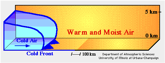
Figure 1: Lift associated with a cold front.
Near large bodies of water, such as the Great Lakes, the relatively small-scale and thermally-driven flow of air associated with lake breezes can also promote upward motion – particularly early in the boating season when the lakes are relatively cold. Although far less dynamic than its large-scale cousin, the leading edge of a lake breeze moving inland (lake breeze front) behaves like a small-scale cold front, and when conditions are right, it can promote the development of thunderstorms.
Occasionally, developing thunderstorms benefit from the combination of two sources of lift. Such was the case in Chicago on July 13, 2019.
Chicago Thunderstorms – July 13, 2019
Saturday, July 13, 2019 was expected to be hot and sultry in the Chicago area, with temperatures reaching into the low 90s and dew points approaching the upper 60s. At 8:00 am, the temperature at Midway Airport was already in the upper 70s. A weak slow-moving cold front was expected to move into northern Illinois and trigger showers and perhaps a few thunderstorms by early evening (figure 2).
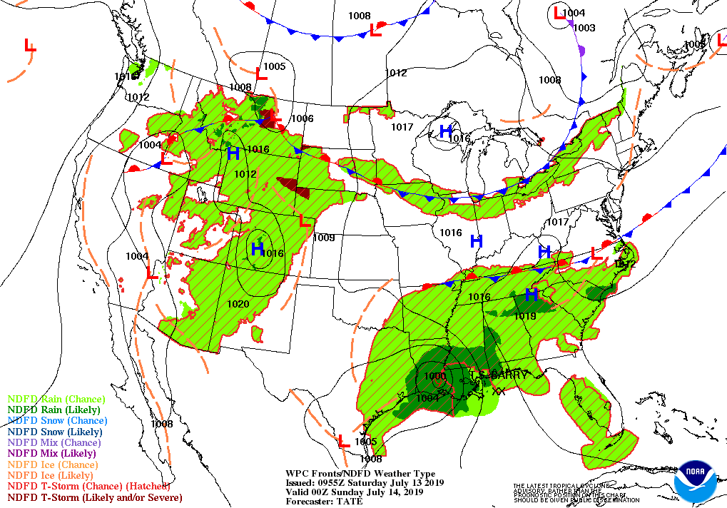
Figure 2: Surface forecast valid at 7:00 pm on July 13, 2019
Through the morning of July 13th, winds along the Lake Michigan shore were westerly, courtesy of an area of high pressure centered over downstate Illinois. The wind observations from the Harrison-Dever crib and Calumet Harbor appear in figures 3 and 4.

Figure 3: Harrison-Dever Crib observations.

Figure 4: Calumet Harbor observations.
The easterly onshore winds that are the hallmark of a lake breeze in Chicago were first observed at the Harrison-Dever crib between 1:00 pm and 1:30 pm as the wind veered from 270 degrees to 40 degrees. Approximately an hour later, the winds at Calumet Harbor veered from 248 degrees to 25 degrees. Although there were fluctuations in direction, onshore winds persisted at both stations through early evening. The lake breeze pressed inland and reached Midway airport sometime between 3:00 pm and 4:00 pm (click here for the details).
As the lake breeze moved inland, it picked up dust, insects, and other particles that made it detectable by National Weather Service (NWS) Doppler Weather radar. Base reflectivity imagery from the NWS radar station at Chicago (KLOT) from 3:02 pm (figure 5) and 5:10 pm (figure 6) show the leading edge of the lake breeze and its steady westward advance.

Figure 5: Base reflectivity at 3:02 pm. Click here for an annotated version.
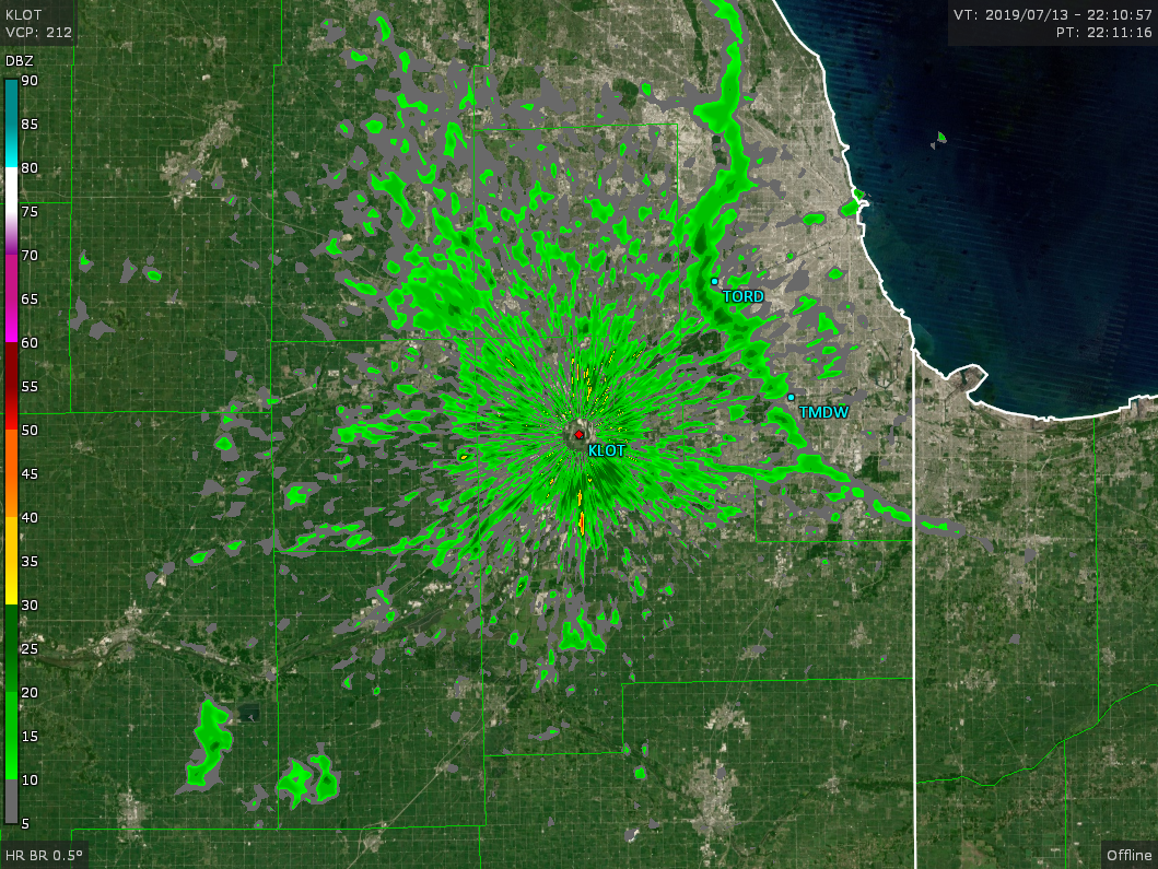
Figure 6: Base reflectivity at 5:10 pm. Click here for an annotated version.
The base reflectivity image at 6:20 pm (figure 7) shows a few showers along the approaching cold front (click here for the surface weather map), an intensifying thunderstorm northwest of the radar station, and the location of the lake breeze which had pushed well inland.

Figure 7: Base reflectivity at 6:20 pm.
The showers along the cold front in north-central and northwestern Illinois quickly dissipated. In contrast, the thunderstorm near the intersection of the cold front and the lake breeze front continued to flourish in response to the combined lift provided by both boundaries. The favorable dynamics led to the formation of an additional storm near Midway Airport at approximately 7:00 pm. This storm strengthened quickly over the next hour and produced two 60 mph gusts in northwest Indiana. (Click on the image below to view an animation of the thunderstorms that formed near the intersection of the cold and lake breeze front.)
As mentioned above, the thunderstorm that formed near Midway Airport achieved severe status (a wind gust greater than 50 knots) in northwest Indiana slightly after 8:00 pm (figure 8). Echo tops, a special type of radar image that shows overall storm height (figure 9) indicated the thunderstorm reached a height of 50,000 feet! The storm’s height and the low angle of the Sun (it was late evening) caused the storm to cast a shadow over much of northwest Indiana that was captured by a weather satellite (click here for the satellite image).

Figure 8: Base reflectivity at 8:16 pm.
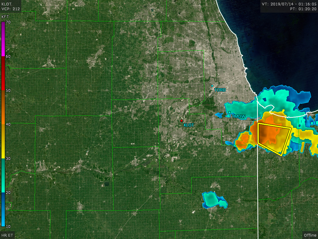
Figure 9: Echo tops at 8:16 pm.