
Introduction
Whether it’s a beer can race or a top tier regatta, weather often adds a bit of excitement to sailboat racing. This was particularly true for Windsor Yacht Club’s Wednesday night race on Lake St. Clair, held on August 24, 2016 (click here for a map). Not long after the 7:00 pm start, an unwarned cluster of thunderstorms rolled over the course, quickly producing 30 knot winds and torrential rain.

Figure 1: Wind observations from Night Moves, a J120.
At approximately 7:18 pm during the height of the wind and rain, Nauti Boys (a J120) was struck by lightning. The strike left the vessel’s carbon fiber mast smoldering and the crew scrambling to keep the boat afloat due to blown out thru-hull fittings and other holes. (Fortunately, none of Nauti Boys’ crew was injured, although the boat is likely a total loss.) Several damage pictures can be viewed here.
And if high winds and a lightning strike weren’t enough excitement for the evening, a few minutes later drywall, insulation, and other debris rained down on the fleet courtesy of a weak tornado near La Salle, Ontario (click here for news report). What led to this craziness?
The Forecast
The Lake St. Clair marine forecast issued by the National Weather Service (NWS) at 9:43 am on Wednesday morning mentioned a chance of showers and thunderstorms by mid-afternoon. Southerly winds from 10 to 15 knots during the afternoon were expected to veer towards the southwest and diminish to 5 to 10 knots during the evening. The trigger for the showers and thunderstorms was an approaching cold front extending from a low north of Lake Superior (click here for the surface forecast).
In their early morning Hazardous Weather Outlook, the NWS warned that the “storms may produce wind gusts in excess of 35 knots, but only an isolated storm will carry the potential for gusts in excess of 50 knots.” The low probability of severe thunderstorms (hail => 1”, wind gust => 50 knots or a tornado) was reinforced by the Convective Outlook (figure 1) issued by the Storm Prediction Center (SPC), which categorized the overall risk as Marginal for Lake St. Clair. While the probability of thunderstorms producing damaging wind gusts near Lake St. Clair was less than 5% (click here), the probability of a tornado was 0% (click here).

Figure 2: Day 1 Convective Outlook from NOAA’s Storm Prediction Center.
In addition to the Convective Outlook, the SPC issued Thunderstorm Outlooks (figures 3 to 6), in four-hour increments) displaying the probability of both severe and non-severe thunderstorms occurring on Wednesday. While the probability of thunderstorms on Lake St. Clair didn’t exceed 10% at any time on Wednesday, most of lower Michigan was under a 40% probability from 4:00 pm to 8:00 pm.


Thunderstorms On The Race Course
At 6:00 pm, an hour before the start of the race, a disorganized cluster of thunderstorms was approaching Lake St. Clair from the southwest. While no watches or warnings were associated with these storms, nearby thunderstorms in northeastern Indiana and northwestern Ohio were covered by tornado warnings, represented by purple polygons on the radar image (figure 5). Over the next hour, these storms approaching Lake St. Clair strengthened and merged into a large multi-cellular cluster nearly the size of the lake itself (click here for a loop of radar images).
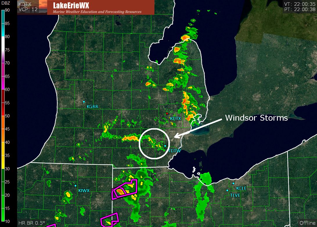
Figure 7: Detroit NWS radar image at 6:00 pm on August 24, 2016.
Shortly after the 7:00 pm start, the leading edge of the thunderstorm cluster was approximately 10 miles southwest of the Windsor Yacht Club (figure 6) and moving northeast at 25 knots.

Figure 8: NWS Detroit radar at 7:01 pm on August 24, 2016.
Radar Identifies Storm Rotation
Reflectivity is the most commonly recognized type of radar imagery and is used to assess the overall structure and size of weather features (such as in figures 5 and 6). But NWS radar collects far more data than just reflectivity.
Since NWS radar measures the Doppler shift, the station can determine the motion (speed and direction) of particles such as raindrops, hail, debris, etc., associated with the thunderstorm. This motion is always shown relative to the radar station and is known as velocity radar imagery. The scale on velocity imagery is in knots, with negative values (greens and blue shading) indicating wind blowing toward the station (inbound) and positive values (reds and yellows) representing wind blowing away from the station (outbound).
Velocity imagery is very helpful in determining the motion of a thunderstorm, but circulations within a storm, such as a tornado or waterspout, can be masked by the overall movement of the storm. This is particularly true with fast moving storms. A special type of imagery—storm-relative velocity—shows these internal circulations by subtracting the overall motion of the thunderstorm from the collected data. (Note: Most of the iOS and Android radar applications I am familiar with offer velocity and storm-relative velocity radar products.)

Figure 9: NWS Detroit storm-relative velocity radar image at 7:01 pm on August 24, 2016.
The annotated storm-relative image at 7:01 pm (figure 9) shows clear indication of rotation in a thunderstorm near the trailing edge of the cluster. Rotation is deduced by the presence of outbound winds (in red) directly adjacent to inbound winds (in green) (click here for a zoom-in version of the radar image).
Due to the curvature of the Earth, the height of a radar beam increases as distance from the station increases. For example, beam height in the vicinity of the annotated rotation (33 nm from the NWS radar station) was approximately 2,500 feet above the surface. While the presence of a weak tornado can’t be confirmed by radar alone, an important ingredient—low-level rotation—was clearly present within the thunderstorm 15 to 20 minutes before debris rained down on the fleet.
Around the time Nauti Boys was struck by lightning (7:18 pm), the strongest thunderstorm in the cluster (and accompanying low-level rotation) was directly over the race course (figures 10 and 11).


The low-level rotation was consistently visible on radar from 7:01 pm until 7:30 pm, approximately 10 minutes after the debris rained down on the fleet (click here for a radar loop). Eyewitness reports and a damage survey conducted by Environment Canada confirmed that an F1 tornado with winds of 80 to 110 mph occurred near La Salle shortly after 7:00 pm.
Conclusion
This event reinforces the challenges associated with forecasting severe weather and the need for sailors to stay “weather aware” when thunderstorms are in the neighborhood. As participants in the Windsor Yacht Club’s August 24 race experienced, anything can happen on the race course.
Acknowledgements
I would like to thank Eric Petersen of Night Moves letting me know about the incident and for providing a detailed timeline of the event and log of the wind conditions.
